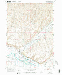
1952 Map of Birding Island
USGS Topo · Published 1976About this map
Birding Island dominates the bend of the Payette River in this 1952 study of the Idaho-Payette county border. The landscape is defined by the hydrologic management of the valley, featuring a Diversion Dam and an intricate network of waterways including Little Willow Creek, Big Willow Creek, and the curiously named Forty-nine Slough. These water sources support a semi-arid terrain where isolated infrastructure like a Water Tank and Windmill stand as markers of rural utility.
Find a feature on this map
37 named features on this map. Tap any name to fly to it.
Don’t see what you’re looking for? This feature index may not catch every label — zoom into the map to look around manually.
Map Details
Editions of this 1952 Birding Island Map
3 editions found
Other maps of this area

1897 · Weiser
USGS Topo · 1:125,000

1898 · Nampa
USGS Topo · 1:125,000

1951 · Payette
USGS Topo · 1:24,000

1951 · Weiser South
USGS Topo · 1:24,000

1952 · Weiser Cove
USGS Topo · 1:24,000

1952 · Birding Island
USGS Topo · 1:24,000

1955 · Baker
USGS Topo · 1:250,000

1955 · Boise
USGS Topo · 1:250,000

1958 · Boise
USGS Topo · 1:250,000

1959 · Baker
USGS Topo · 1:250,000