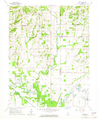
1964 Map of Birds
USGS Topo · Published 1965About this map
Birds and Pinkstaff anchor this mid-1960s survey of the Illinois borderlands, where the New York Central railroad cuts a straight north-south line through the heart of the landscape. The region is defined by its transition from the upland prairies of Montgomery and Bond to the alluvial bottoms of the Old Channel Embarras River. The map reveals a dense network of local landmarks essential for family history research, including the Brookside Sch, Mt Zion Ch, and numerous rural burial grounds like Otterbein Cem and Dollahan Cem.
Find a feature on this map
51 named features on this map. Tap any name to fly to it.
Don’t see what you’re looking for? This feature index may not catch every label — zoom into the map to look around manually.
Map Details
Editions of this 1964 Birds Map
This is the sole edition of this map. No revisions or reprints were ever made.
Other maps of this area

1910 · Hardinville
USGS Topo · 1:62,500

1911 · Sumner
USGS Topo · 1:62,500

1913 · Sumner
USGS Topo · 1:62,500

1915 · Vincennes
USGS Topo · 1:62,500

1917 · Birds
USGS Topo · 1:62,500

1942 · Birds
USGS Topo · 1:62,500

1944 · Vincennes
USGS Topo · 1:62,500

1956 · Vincennes
USGS Topo · 1:250,000

1957 · Vincennes
USGS Topo · 1:250,000

1958 · Vincennes
USGS Topo · 1:250,000