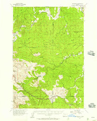
1955 Map of Birkenfeld
USGS Topo · Published 1957About this map
The Nehalem River winds through this mid-1950s landscape of the Oregon Coast Range, a region defined by its timber industry and complex topography. Small settlements such as Birkenfeld and Mist serve as anchors in the north, while the presence of Camp McGregor and the Buster Camp (Site) highlight the area's history of logging operations. Traces of previous infrastructure are visible in the Old Railroad Grade and the Vesper Sch (Aban'd), marking shifts in the local community as the road network evolved. The southern portion of the map transitions into the Sunset Highway State Park, where the Sunset Highway provides a modern transit corridor alongside the headwaters of numerous creeks including Rock Creek and Wolf Creek. The map also records specialized industrial sites like the Timber Substation and the Sterling Guard Sta, reflecting the management of these vast forested lands.
Find a feature on this map
48 named features on this map. Tap any name to fly to it.
Don’t see what you’re looking for? This feature index may not catch every label — zoom into the map to look around manually.
Map Details
Editions of this 1955 Birkenfeld Map
3 editions found
Other maps of this area

1919 · Mayger
USGS Topo · 1:62,500

1937 · Enright
USGS Topo · 1:62,500

1939 · Saddle Mountain
USGS Topo · 1:62,500

1940 · Svensen
USGS Topo · 1:62,500

1940 · Vernonia
USGS Topo · 1:62,500

1941 · Keasey
USGS Topo · 1:62,500

1941 · Timber
USGS Topo · 1:62,500

1941 · Enright
USGS Topo · 1:62,500

1941 · Gales Creek
USGS Topo · 1:62,500

1941 · Clatskanie
USGS Topo · 1:62,500