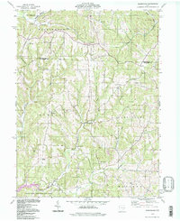
1994 Map of Birmingham
USGS Topo · Published 1998About this map
Salt Fork Lake and its surrounding wildlife area anchor the southern portion of this landscape, where the borders of Guernsey and Tuscarawas counties meet. The terrain is defined by a dense network of drainages including Clear Fork, Rocky Fork, and Dunlap Creek, which carve through the hills of Washington and Monroe townships. Rural life is centers around the small settlements of Birmingham and Peoli, with local genealogy well-represented by several country churches and burial grounds. Notable sites include Irish Ridge Ch, the Salem-Washington Sch, and High Hill Cem. Evidence of resource extraction is present through scattered Strip Mine operations and an Oil Well near the Washington township line, while a prominent Pipeline cuts across the northern ridges. This map documents a region where traditional agricultural settlement patterns and small-town junctions persist alongside significant state-managed conservation lands.
Find a feature on this map
39 named features on this map. Tap any name to fly to it.
Don’t see what you’re looking for? This feature index may not catch every label — zoom into the map to look around manually.
Map Details
Editions of this 1994 Birmingham Map
This is the sole edition of this map. No revisions or reprints were ever made.
Other maps of this area

1909 · Antrim
USGS Topo · 1:48,000

1909 · Uhrichsville
USGS Topo · 1:62,500

1909 · Cambridge
USGS Topo · 1:62,500

1911 · Antrim
USGS Topo · 1:62,500

1911 · Uhrichsville
USGS Topo · 1:62,500

1911 · Newcomerstown
USGS Topo · 1:62,500

1912 · Cambridge
USGS Topo · 1:62,500

1913 · Newcomerstown
USGS Topo · 1:62,500

1943 · Newcomerstown
USGS Topo · 1:62,500

1951 · Canton
USGS Topo · 1:250,000