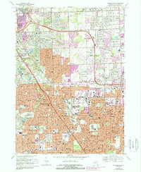
1981 Map of Birmingham
USGS Topo · Published 1989About this map
Birmingham and the neighboring communities of Troy, Royal Oak, and Berkley define the landscape of southern Oakland County in this early 1980s record. The Grand Trunk Western railroad corridor slices through the region, providing the industrial backbone for the residential growth radiating from Woodward Ave. The map captures a transitional era where traditional neighborhood schools like Quarton Sch and Seaholm High Sch are surrounded by intensifying suburban development, indicated by updated urban areas in purple.
Find a feature on this map
96 named features on this map. Tap any name to fly to it.
Don’t see what you’re looking for? This feature index may not catch every label — zoom into the map to look around manually.
Map Details
Editions of this 1981 Birmingham Map
This is the sole edition of this map. No revisions or reprints were ever made.
Other maps of this area

1905 · Wayne
USGS Topo · 1:62,500

1905 · Detroit
USGS Topo · 1:62,500

1907 · Pontiac
USGS Topo · 1:62,500

1908 · Rochester
USGS Topo · 1:62,500

1912 · Wayne
USGS Topo · 1:62,500

1918 · Detroit
USGS Topo · 1:62,500

1924 · Detroit
USGS Topo · 1:62,500

1934 · Detroit
USGS Topo · 1:62,500

1936 · Warren
USGS Topo · 1:31,680

1936 · Birmingham
USGS Topo · 1:31,680