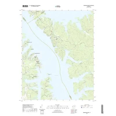
2019 Map of Birmingham Point
USGS Topo · Published 2019About this map
Grand Rivers sits at the northern neck of a narrow land bridge where the Barkley Canal connects the sprawling waters of Lake Barkley and Kentucky Lake. This map details the intricate shoreline of the Tennessee Valley Divide, a landscape defined by deep inlets like Pisgah Bay, Smith Bay, and Demumbers Bay. The area serves as a significant recreational and residential corridor, evidenced by communities such as Cambridge Shores, Buena Vista, and The Moors along the western shore. Inland, the rugged terrain is crossed by the N S Trail and The Trace Rd, highlighting the region's importance for both transit and forest management. Genealogists can find several isolated burial sites, including the Birmingham Island Cemetery and Barnett Cem, which remain as markers of the area's rural history before the major hydroelectric and navigation projects of the mid-20th century transformed the Tennessee and Cumberland River valleys.
Find a feature on this map
87 named features on this map. Tap any name to fly to it.
Don’t see what you’re looking for? This feature index may not catch every label — zoom into the map to look around manually.
Map Details
Editions of this 2019 Birmingham Point Map
This is the sole edition of this map. No revisions or reprints were ever made.
Other maps of this area

1928 · Eddyville
USGS Topo · 1:48,000

1929 · Smithland
USGS Topo · 1:62,500

1931 · Eddyville
USGS Topo · 1:62,500

1936 · Eddyville
USGS Topo · 1:48,000

1936 · Mont
USGS Topo · 1:24,000

1936 · Fenton
USGS Topo · 1:24,000

1936 · Grand Rivers
USGS Topo · 1:24,000

1936 · Hardin
USGS Topo · 1:24,000

1936 · Smithland
USGS Topo · 1:48,000

1936 · Hiatt
USGS Topo · 1:24,000