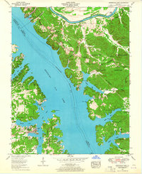
1955 Map of Birmingham Point
USGS Topo · Published 1964About this map
Kentucky Lake and the Cumberland River dominate this mid-century landscape in the area known as Between the Rivers. The terrain is defined by the high-water elevation of the reservoir, which has reshaped the valley's geography and inundated earlier lowlands. At the northern edge, the community of Grand Rivers serves as a gateway near the Badgett Coal Terminal, highlighting the region's industrial connection to river transport. Moving south into the Kentucky Woodlands Wildlife Refuge, the map reveals a deeply etched network of inlets including Pisgah Bay and Smith Bay. This 1955 field revision captures a transition in local history, preserving the locations of numerous family burial grounds like the Nickell and Holland cemeteries, alongside rural institutions such as the Oakland School and Star Lime Works Church. The presence of Birmingham Point and its associated Birmingham Cemetery serves as a marker for the community that once existed before the formation of the lake.
Find a feature on this map
47 named features on this map. Tap any name to fly to it.
Don’t see what you’re looking for? This feature index may not catch every label — zoom into the map to look around manually.
Map Details
Editions of this 1955 Birmingham Point Map
2 editions found
Other maps of this area

1928 · Eddyville
USGS Topo · 1:48,000

1929 · Smithland
USGS Topo · 1:62,500

1931 · Eddyville
USGS Topo · 1:62,500

1936 · Eddyville
USGS Topo · 1:48,000

1936 · Mont
USGS Topo · 1:24,000

1936 · Fenton
USGS Topo · 1:24,000

1936 · Grand Rivers
USGS Topo · 1:24,000

1936 · Hardin
USGS Topo · 1:24,000

1936 · Smithland
USGS Topo · 1:48,000

1936 · Hiatt
USGS Topo · 1:24,000