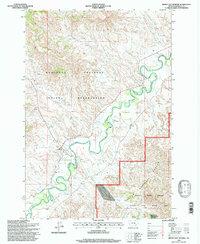
1995 Map of Birney Day School
USGS Topo · Published 1998About this map
The Northern Cheyenne Indian Reservation and the Tongue River valley dominate this mid-1990s landscape in Rosebud County. The settlement of Birney sits along the western bank of the river, serving as a focal point for local life alongside the Birney Day School and a nearby Cem. The map reveals a complex water management system, most notably the Cheyenne Ditch which parallels the river's winding course through the valley floor. To the southeast, the terrain shifts into the Custer National Forest and the Tongue River Breaks, an area dedicated to a large Hiking and Riding Area. The inclusion of Nance Landing Field and numerous named springs and creeks, such as Pawnee Creek and Mission Creek, provides a detailed look at the local geography of this ranching and reservation land in eastern Montana.
Find a feature on this map
22 named features on this map. Tap any name to fly to it.
Don’t see what you’re looking for? This feature index may not catch every label — zoom into the map to look around manually.
Map Details
Editions of this 1995 Birney Day School Map
This is the sole edition of this map. No revisions or reprints were ever made.
Other maps of this area

1954 · Hardin
USGS Topo · 1:250,000

1957 · Hardin
USGS Topo · 1:250,000

1958 · Hardin
USGS Topo · 1:250,000

1958 · Fisher Butte
USGS Topo · 1:24,000

1958 · Hollowwood Creek
USGS Topo · 1:24,000

1966 · Browns Mountain
USGS Topo · 1:24,000

1966 · Ashland
USGS Topo · 1:24,000

1966 · Birney Day School
USGS Topo · 1:24,000

1966 · Poker Jim Butte
USGS Topo · 1:24,000
1966 · Green Creek
USGS Topo · 1:24,000