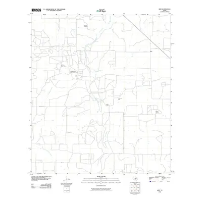
2010 Map of Biry
USGS Topo · Published 2010About this map
Hondo Creek and its various tributaries, including Live Oak Creek and Brier Branch, define the rural geography of this Medina County landscape. The small settlement of Biry sits in the northeast, while the rest of the quadrangle is marked by large ranching and industrial footprints. The Adams Ranch and the nearby Adams Oil Field illustrate the dual reliance on livestock and mineral extraction that characterizes this part of Texas. Water management is a visible priority for local landowners, evidenced by infrastructure like George Wilson Lake Number 1 Dam and its sister reservoir. For genealogists, the map preserves the location of family-named burial sites such as Mussman Cemetery and Howard Cemetery, providing critical spatial context for family histories tied to this creek-crossed terrain.
Find a feature on this map
27 named features on this map. Tap any name to fly to it.
Don’t see what you’re looking for? This feature index may not catch every label — zoom into the map to look around manually.
Map Details
Editions of this 2010 Biry Map
This is the sole edition of this map. No revisions or reprints were ever made.
Other maps of this area

1942 · Natalia
USGS Topo · 1:62,500

1954 · San Antonio
USGS Topo · 1:250,000

1956 · New Fountain
USGS Topo · 1:62,500

1957 · San Antonio
USGS Topo · 1:250,000

1964 · Ghost Hill
USGS Topo · 1:24,000

1964 · Castroville
USGS Topo · 1:24,000

1964 · Devine
USGS Topo · 1:24,000
1964 · Moore
USGS Topo · 1:24,000
1964 · Wilson Ranch
USGS Topo · 1:24,000
1964 · Biry
USGS Topo · 1:24,000