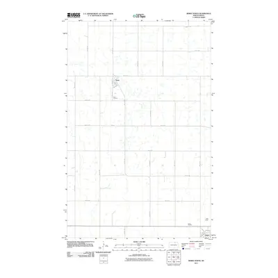
2011 Map of Bisbee North
USGS Topo · Published 2011About this map
Perth and the northern edge of Bisbee anchor this agricultural landscape in Towner County, where the rigid grid of the Public Land Survey System defines the movement of people and resources. Captured in 2011, the map reveals a prairie topography marked by numerous small, seasonal water bodies and depressions typical of the region's glacial history. Long, straight section roads like 92nd St NE and 85th St NE cross the territory, connecting isolated farmsteads to the primary arterial US Hwy 281. Genealogical interest is found at Perth Cemetery and Bisbee Cemetery, while the presence of Lyster Field near the southern boundary suggests the intersection of aviation with the local farming economy. The map illustrates a rural North Dakota community maintaining its structure through established town sites and a pervasive network of numbered gravel and paved roads.
Find a feature on this map
19 named features on this map. Tap any name to fly to it.
Don’t see what you’re looking for? This feature index may not catch every label — zoom into the map to look around manually.
Map Details
Editions of this 2011 Bisbee North Map
This is the sole edition of this map. No revisions or reprints were ever made.
Other maps of this area

1953 · Devils Lake
USGS Topo · 1:250,000

1956 · Devils Lake
USGS Topo · 1:250,000

1970 · Hansboro SW
USGS Topo · 1:24,000

1970 · Hansboro SE
USGS Topo · 1:24,000

1970 · Rolla
USGS Topo · 1:24,000

1971 · Bisbee South
USGS Topo · 1:24,000

1971 · Considine
USGS Topo · 1:24,000

1971 · Mylo
USGS Topo · 1:24,000

1971 · Bisbee North
USGS Topo · 1:24,000
1971 · Big Coulee Dam
USGS Topo · 1:24,000