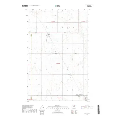
2020 Map of Bisbee North
USGS Topo · Published 2020About this map
The northern edge of Towner County unfolds across this prairie landscape, where the small communities of Perth and Bisbee serve as central points for the surrounding agricultural sections. The map reveals a highly structured grid of section lines and gravel routes, such as Picton Rd and 92nd St NE, reflecting the enduring influence of the Public Land Survey System. Genealogical interest is concentrated in the cluster of burial grounds near the town sites, including Saint Pauls Presbyterian Cem, Holy Rosary Cem, and the Bisbee Cem. The natural geography is defined by subtle depressions and the prominent Big Coulee, which provides a break in the otherwise level plains of North Dakota. This modern survey shows how these rural townships have maintained their essential layout for generations, with small-town street names like Head St and Main St anchoring the community identities.
Find a feature on this map
33 named features on this map. Tap any name to fly to it.
Don’t see what you’re looking for? This feature index may not catch every label — zoom into the map to look around manually.
Map Details
Editions of this 2020 Bisbee North Map
This is the sole edition of this map. No revisions or reprints were ever made.
Other maps of this area

1953 · Devils Lake
USGS Topo · 1:250,000

1956 · Devils Lake
USGS Topo · 1:250,000

1970 · Hansboro SW
USGS Topo · 1:24,000

1970 · Hansboro SE
USGS Topo · 1:24,000

1970 · Rolla
USGS Topo · 1:24,000

1971 · Bisbee South
USGS Topo · 1:24,000

1971 · Considine
USGS Topo · 1:24,000

1971 · Mylo
USGS Topo · 1:24,000

1971 · Bisbee North
USGS Topo · 1:24,000
1971 · Big Coulee Dam
USGS Topo · 1:24,000