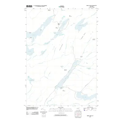
2010 Map of Bisby Lakes
USGS Topo · Published 2010About this map
Bisby Lodge stands at the heart of this high-elevation wilderness, situated between the north shore of First Lake and the slopes of Trusty Mountain. This area is defined by a dense network of connected water bodies, including Woodhull Lake, Canachagala Lake, and the primary chain of the Bisby Lakes. These waters feed into significant drainage systems such as the North Branch and Middle Branch Black River, which carve through the terrain near landmarks like Ice Cave Mountain and Ice Cave Valley.
Find a feature on this map
53 named features on this map. Tap any name to fly to it.
Don’t see what you’re looking for? This feature index may not catch every label — zoom into the map to look around manually.
Map Details
Editions of this 2010 Bisby Lakes Map
This is the sole edition of this map. No revisions or reprints were ever made.
Other maps of this area

1897 · Remsen
USGS Topo · 1:62,500

1900 · Remsen
USGS Topo · 1:62,500

1900 · Wilmurt
USGS Topo · 1:62,500

1901 · Old Forge
USGS Topo · 1:62,500

1902 · Wilmurt
USGS Topo · 1:62,500

1912 · Mc Keever
USGS Topo · 1:62,500
1946 · North Wilmurt
USGS Topo · 1:24,000
1947 · North Wilmurt
USGS Topo · 1:31,680

1950 · Utica
USGS Topo · 1:250,000
1954 · Ohio
USGS Topo · 1:62,500