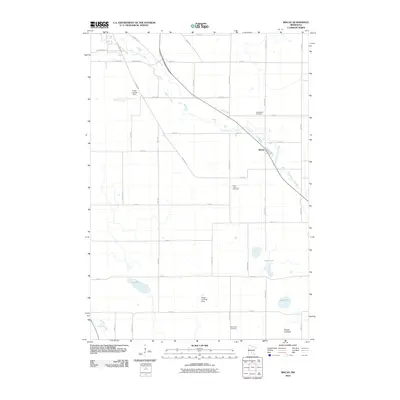
2010 Map of Biscay
USGS Topo · Published 2010About this map
The South Fork Crow River meanders through the heart of this McLeod County landscape, anchoring the small settlement of Biscay. This agricultural region is defined by a grid of rural routes such as County Hwy 8 and Nature Ave, connecting isolated farmsteads and specialized features like the Quast Landing Strip and Ewald Landing Strip. The map provides a clear look at the community's early social foundations, showing the Evangelical Cemetery, Saint John's Cemetery, and Emmanuel Cemetery distributed across the countryside.
Find a feature on this map
44 named features on this map. Tap any name to fly to it.
Don’t see what you’re looking for? This feature index may not catch every label — zoom into the map to look around manually.
Map Details
Editions of this 2010 Biscay Map
This is the sole edition of this map. No revisions or reprints were ever made.
Other maps of this area

1953 · New Ulm
USGS Topo · 1:250,000

1957 · New Ulm
USGS Topo · 1:250,000

1958 · New Ulm
USGS Topo · 1:250,000

1958 · Gaylord
USGS Topo · 1:62,500

1958 · Glencoe
USGS Topo · 1:62,500

1958 · Winthrop
USGS Topo · 1:62,500

1958 · Hutchinson
USGS Topo · 1:62,500

1967 · New Ulm
USGS Topo · 1:250,000
1982 · Silver Lake
USGS Topo · 1:24,000
1982 · Heatwole
USGS Topo · 1:24,000