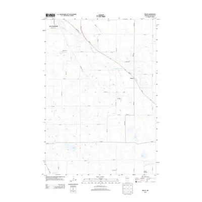
2013 Map of Biscay
USGS Topo · Published 2013About this map
The S Fork Crow River cuts through this portion of McLeod County, anchoring a landscape defined by the small settlement of Biscay and the southern outskirts of Hutchinson. This 2013 survey illustrates the agrarian layout of the region, where a dense grid of township roads like Nature Ave and Lace Ave connects scattered homesteads and community landmarks. Genealogists will find several burial grounds noted, including Evangelical Cem, Saint John's Cem, and Emmanuel Cem, which serve as quiet markers of the area's long-standing rural congregations.
Find a feature on this map
43 named features on this map. Tap any name to fly to it.
Don’t see what you’re looking for? This feature index may not catch every label — zoom into the map to look around manually.
Map Details
Editions of this 2013 Biscay Map
This is the sole edition of this map. No revisions or reprints were ever made.
Other maps of this area

1953 · New Ulm
USGS Topo · 1:250,000

1957 · New Ulm
USGS Topo · 1:250,000

1958 · New Ulm
USGS Topo · 1:250,000

1958 · Gaylord
USGS Topo · 1:62,500

1958 · Glencoe
USGS Topo · 1:62,500

1958 · Winthrop
USGS Topo · 1:62,500

1958 · Hutchinson
USGS Topo · 1:62,500

1967 · New Ulm
USGS Topo · 1:250,000
1982 · Silver Lake
USGS Topo · 1:24,000
1982 · Heatwole
USGS Topo · 1:24,000