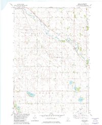
1982 Map of Biscay
USGS Topo · Published 1982About this map
Biscay sits at the heart of this agricultural landscape in the early 1980s, where the winding South Fork Crow River cuts through Hassen Valley and Rich Valley. The map reveals a highly managed hydrological system, where Co Ditch No 26 and Co Ditch No 27 drain the surrounding fields into the river system. This area, primarily characterized by glacial depressions and wetlands, is dotted with numerous small bodies of water including Lake Mary, Ryan Lake, and Clear Lake.
Find a feature on this map
27 named features on this map. Tap any name to fly to it.
Don’t see what you’re looking for? This feature index may not catch every label — zoom into the map to look around manually.
Map Details
Editions of this 1982 Biscay Map
This is the sole edition of this map. No revisions or reprints were ever made.
Other maps of this area

1953 · New Ulm
USGS Topo · 1:250,000

1957 · New Ulm
USGS Topo · 1:250,000

1958 · New Ulm
USGS Topo · 1:250,000

1958 · Gaylord
USGS Topo · 1:62,500

1958 · Glencoe
USGS Topo · 1:62,500

1958 · Winthrop
USGS Topo · 1:62,500

1958 · Hutchinson
USGS Topo · 1:62,500

1967 · New Ulm
USGS Topo · 1:250,000
1982 · Silver Lake
USGS Topo · 1:24,000
1982 · Heatwole
USGS Topo · 1:24,000