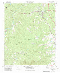
1983 Map of Biscoe
USGS Topo · Published 1983About this map
Biscoe and Candor serve as the primary anchors for this region of Montgomery County, connected by the Norfolk Southern line. The map illustrates a landscape where small-scale agriculture and early technical education, represented by the Montgomery Tech Institute, meet the protected woodlands of the Uwharrie National Forest. The drainage patterns are defined by the Little River and its numerous tributaries like Densons Creek and Turkey Creek, which carved the terrain long before modern infrastructure arrived.
Find a feature on this map
59 named features on this map. Tap any name to fly to it.
Don’t see what you’re looking for? This feature index may not catch every label — zoom into the map to look around manually.
Map Details
Editions of this 1983 Biscoe Map
This is the sole edition of this map. No revisions or reprints were ever made.
Other maps of this area

1942 · Troy
USGS Topo · 1:125,000

1949 · Jackson Springs
USGS Topo · 1:62,500

1950 · Norman
USGS Topo · 1:24,000

1953 · Raleigh
USGS Topo · 1:250,000

1954 · Raleigh
USGS Topo · 1:250,000

1956 · Mount Gilead East
USGS Topo · 1:24,000

1956 · Harrisville
USGS Topo · 1:24,000

1957 · Troy
USGS Topo · 1:62,500
1957 · Jackson Springs
USGS Topo · 1:62,500

1974 · Candor
USGS Topo · 1:24,000