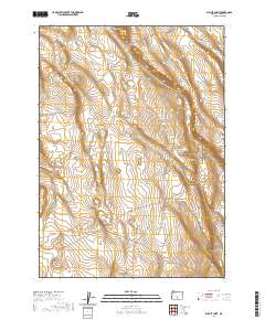
2020 Map of Biscuit Point
USGS Topo · Published 2020About this map
Twin Buttes stands as a prominent landmark in this high-desert landscape of Lake County, where the terrain is defined by dry canyons and isolated water sources. The map reveals a remote pastoral environment where life centers around essential features like Keen Waterhole and the broad depressions of Big Basin. Surveyed in the early 21st century, the area is crisscrossed by established routes such as Co Rd 6184 and Co Rd 2-06, which navigate the elevation changes between the heights of Biscuit Point and the depths of Sand Canyon. The township and range lines of t31s r21e and t32s r20e provide the structural grid for this sparsely populated portion of the Oregon desert, illustrating the enduring nature of public land surveys in managing the western rangeland.
Find a feature on this map
11 named features on this map. Tap any name to fly to it.
Don’t see what you’re looking for? This feature index may not catch every label — zoom into the map to look around manually.
Map Details
Editions of this 2020 Biscuit Point Map
This is the sole edition of this map. No revisions or reprints were ever made.
Other maps of this area

1955 · Klamath Falls
USGS Topo · 1:250,000

1958 · Klamath Falls
USGS Topo · 1:250,000

1966 · Coglan Buttes NE
USGS Topo · 1:24,000

1966 · Coglan Buttes
USGS Topo · 1:24,000

1968 · Lake Abert North
USGS Topo · 1:24,000

1974 · Lake Abert
USGS Topo · 1:100,000
1984 · Sawed Horn
USGS Topo · 1:24,000
1984 · Poverty Basin South
USGS Topo · 1:24,000

1985 · Sharp Top
USGS Topo · 1:24,000
1985 · Biscuit Point
USGS Topo · 1:24,000