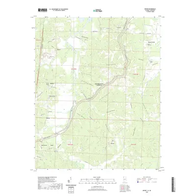
2020 Map of Bishop
USGS Topo · Published 2020About this map
The Natchez Trace Pkwy arcs across this portion of Colbert County, Alabama, tracing a historic travel corridor through a landscape defined by deep-cut hollows and seasonal creek branches. In the rural community of Allsboro, social life is anchored by the Allsboro Methodist Church and the Allsboro Cumberland Presbyterian Church, while surrounding settlements like Burnstown, Maud, and Mynot are linked by a network of winding county roads. The terrain is notably dissected by watercourses such as Bear Creek and Cripple Deer Cr, which have carved out locally named features like Templeton Hollow and McCluskey Hollow. Genealogists will find a wealth of family history sites, including the Liberty Cem, Alsobrook Cem, and Twitty Cem, often located near these early homesteading pockets. The map also captures the state line where Alabama meets Mississippi, marked by the transition from Tishomingo and Colbert counties.
Find a feature on this map
85 named features on this map. Tap any name to fly to it.
Don’t see what you’re looking for? This feature index may not catch every label — zoom into the map to look around manually.
Map Details
Editions of this 2020 Bishop Map
This is the sole edition of this map. No revisions or reprints were ever made.
Other maps of this area

1911 · Iuka
USGS Topo · 1:48,000

1914 · Iuka
USGS Topo · 1:62,500

1924 · Gravelly Springs
USGS Topo · 1:48,000

1925 · Barton
USGS Topo · 1:62,500

1926 · Barton
USGS Topo · 1:48,000

1926 · Gravelly Springs
USGS Topo · 1:62,500

1929 · Barton
USGS Topo · 1:62,500

1935 · Cherokee
USGS Topo · 1:24,000

1935 · Iuka
USGS Topo · 1:24,000

1935 · Pleasant Site
USGS Topo · 1:24,000