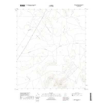
2019 Map of Bissett Mountain
USGS Topo · Published 2019About this map
Bissett Mtn anchors this arid West Texas landscape, surrounded by an intricate network of seasonal drainages that define the local geography. The territory is marked by the presence of Burgess Spring to the southeast, a critical water source in this desert environment. Human activity is evidenced primarily by Benge Ranch Rd, which traverses the central and eastern portions of the map, and a segment of U.S. Route 67 cutting across the northwest corner. The drainage patterns, including Antelope Draw, Jackson Draw, and Booster Mill Draw, illustrate how water moves across the high-altitude terrain toward the surrounding basins. This mapping of Brewster County provides a clear view of the ranching infrastructure and natural landmarks typical of the Trans-Pecos region.
Find a feature on this map
9 named features on this map. Tap any name to fly to it.
Don’t see what you’re looking for? This feature index may not catch every label — zoom into the map to look around manually.
Map Details
Editions of this 2019 Bissett Mountain Map
This is the sole edition of this map. No revisions or reprints were ever made.
Other maps of this area

1894 · Fort Davis
USGS Topo · 1:125,000

1895 · Alpine
USGS Topo · 1:125,000

1897 · Fort Davis
USGS Topo · 1:125,000

1923 · Altuda
USGS Topo · 1:62,500

1929 · Hovey
USGS Topo · 1:125,000

1954 · Fort Stockton
USGS Topo · 1:250,000

1958 · Fort Stockton
USGS Topo · 1:250,000

1972 · Bird Mountain
USGS Topo · 1:24,000

1972 · Elam Mountain
USGS Topo · 1:24,000

1973 · Fort Stockton
USGS Topo · 1:250,000