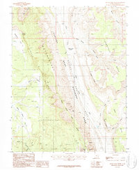
1987 Map of Bitter Creek Divide
USGS Topo · Published 1987About this map
Capitol Reef National Park dominates this landscape, centered on the dramatic geological buckling of the Waterpocket Fold. The 1980s terrain is characterized by massive escarpments and canyon systems, including the Circle Cliffs and the jagged profile of the Oyster Shell Reef. This survey documents a wilderness environment where water and stone have shaped the settlement patterns of Garfield County, Utah. Notable drainage systems like Halls Creek and Bitter Creek carve through the plateau, while names such as Upper Muley Twist Canyon and Grand Gulch speak to the complex navigation required by early travelers. High-altitude landmarks like Tarantula Mesa and Swap Mesa flank the central valley, providing fixed points for backcountry navigation. Strategic water sources such as Brinkerhoff Spring and distinctive features like the Strike Valley Overlook and Double Arch highlight the natural landmarks that guided travelers through this isolated corridor.
Find a feature on this map
23 named features on this map. Tap any name to fly to it.
Don’t see what you’re looking for? This feature index may not catch every label — zoom into the map to look around manually.
Map Details
Editions of this 1987 Bitter Creek Divide Map
2 editions found
Other maps of this area

1885 · San Rafael
USGS Topo · 1:250,000

1885 · Fish Lake
USGS Topo · 1:250,000

1886 · Escalante
USGS Topo · 1:250,000

1886 · Henry Mountains
USGS Topo · 1:250,000

1892 · Henry Mountains
USGS Topo · 1:250,000

1896 · Fish Lake
USGS Topo · 1:250,000

1952 · Notom 4 SE
USGS Topo · 1:24,000

1952 · Notom 4 SW
USGS Topo · 1:24,000

1952 · Notom
USGS Topo · 1:62,500

1953 · Mt Pennell
USGS Topo · 1:62,500