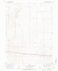
1968 Map of Bitter Creek NE
USGS Topo · Published 1978About this map
The Continental Divide snake through this high desert region of Sweetwater County, defining a landscape of energy extraction and transport during the late 1960s. Industrial activity is concentrated along the southern corridor, where the Oil Field and numerous Gas Wells meet a network of Pipelines. Infrastructure includes the Gas Plant and several remote water sources like Tenmile Well and Mud Lake Well, which were vital for supporting operations in this arid environment. Transportation is dominated by the parallel routes of Interstate 80 and Highway 30, which cut across the southern third of the sheet. The map reveals the complex intersection of natural topography and mid-century industrial development, where Radio Towers and a Gravel Pit stand alongside the seasonal watercourses of Tenmile Draw and Patrick Draw.
Find a feature on this map
18 named features on this map. Tap any name to fly to it.
Don’t see what you’re looking for? This feature index may not catch every label — zoom into the map to look around manually.
Map Details
Editions of this 1968 Bitter Creek NE Map
2 editions found
Other maps of this area

1954 · Rock Springs
USGS Topo · 1:250,000

1958 · Rock Springs
USGS Topo · 1:250,000

1958 · Twelvemile Well
USGS Topo · 1:62,500

1960 · Red Lake
USGS Topo · 1:62,500

1962 · Rock Springs
USGS Topo · 1:250,000

1968 · Bitter Creek NW
USGS Topo · 1:24,000

1968 · Bitter Creek
USGS Topo · 1:24,000

1968 · Black Buttes
USGS Topo · 1:24,000

1968 · Bitter Creek NE
USGS Topo · 1:24,000

1970 · Table Rock
USGS Topo · 1:24,000