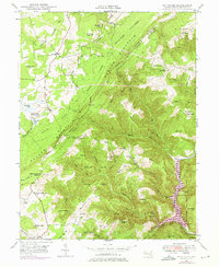
1947 Map of Bittinger
USGS Topo · Published 1975About this map
Bittinger sits high in the Garrett County highlands, serving as a focal point for a landscape defined by the parallel ridges of Meadow Mountain and Big Savage Mtn. This mid-century survey captures the rural character of the region, where life was organized around small mountain settlements and spiritual centers like Meadow Mountain Ch and the Meadow Mountain Mission. The infrastructure of the era is evident in the network of forest roads through the Savage River State Forest and the prominence of the Bittinger Fire Tower, once a critical lookout for the surrounding timberlands.
Find a feature on this map
83 named features on this map. Tap any name to fly to it.
Don’t see what you’re looking for? This feature index may not catch every label — zoom into the map to look around manually.
Map Details
Editions of this 1947 Bittinger Map
3 editions found
Other maps of this area

1895 · Piedmont
USGS Topo · 1:125,000

1899 · Grantsville
USGS Topo · 1:62,500

1899 · Oakland
USGS Topo · 1:62,500

1900 · Accident
USGS Topo · 1:62,500

1900 · Oakland
USGS Topo · 1:62,500

1904 · Grantsville
USGS Topo · 1:62,500

1919 · Elk Garden
USGS Topo · 1:48,000

1920 · Elk Garden
USGS Topo · 1:48,000

1922 · Elk Garden
USGS Topo · 1:62,500

1946 · Grantsville
USGS Topo · 1:24,000