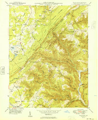
1949 Map of Bittinger
USGS Topo · Published 1949About this map
Meadow Mountain dominates this Maryland landscape, serving as a high-altitude divide between the Casselman River headwaters and the complex drainage of the Savage River State Forest. In the late 1940s, the rural community of Bittinger and the small settlement at North Glade served as local hubs, connected by a network of mountain roads that reached toward isolated family-named peaks like Browning Bear Hill and Contrary Knob.
Find a feature on this map
75 named features on this map. Tap any name to fly to it.
Don’t see what you’re looking for? This feature index may not catch every label — zoom into the map to look around manually.
Map Details
Editions of this 1949 Bittinger Map
2 editions found
Other maps of this area

1895 · Piedmont
USGS Topo · 1:125,000

1899 · Grantsville
USGS Topo · 1:62,500

1899 · Oakland
USGS Topo · 1:62,500

1900 · Accident
USGS Topo · 1:62,500

1900 · Oakland
USGS Topo · 1:62,500

1904 · Grantsville
USGS Topo · 1:62,500

1919 · Elk Garden
USGS Topo · 1:48,000

1920 · Elk Garden
USGS Topo · 1:48,000

1922 · Elk Garden
USGS Topo · 1:62,500

1946 · Grantsville
USGS Topo · 1:24,000