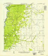
1954 Map of Bivens
USGS Topo · Published 1954About this map
The Sabine River snakes along the western border of this quadrangle, defining the state boundary between Louisiana and Texas. In this corner of Beauregard Parish, the landscape is shaped by the shifting course of the river, leaving behind landforms like Old River, Horseshoe Lake, and Alligator Lake. To the south, the settlement of Bivens serves as a local hub near Green Oak Ch and Boxwood Ch, while the town of Merryville sits in the north along the Gulf Colorado and Santa Fe railroad line. The map reveals the area's timber history through several stretches of Old Logging Railroad Grade, showing how industrial transport once penetrated the dense network of tributaries such as Cypress Creek and Hoosier Creek well before modern highway development dominated the region.
Find a feature on this map
25 named features on this map. Tap any name to fly to it.
Don’t see what you’re looking for? This feature index may not catch every label — zoom into the map to look around manually.
Map Details
Editions of this 1954 Bivens Map
This is the sole edition of this map. No revisions or reprints were ever made.
Other maps of this area

1935 · Wilson Lake
USGS Topo · 1:31,680

1946 · Merryville
USGS Topo · 1:31,680

1947 · Singer
USGS Topo · 1:31,680

1947 · Pujo
USGS Topo · 1:31,680

1947 · Oretta
USGS Topo · 1:31,680

1947 · Wilson Lake
USGS Topo · 1:31,680

1947 · Hyatt
USGS Topo · 1:31,680

1947 · Bivens
USGS Topo · 1:31,680

1949 · Bancroft
USGS Topo · 1:31,680

1952 · Lake Charles
USGS Topo · 1:250,000