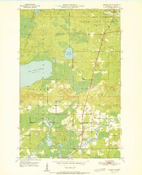
1951 Map of Biwabik NW
USGS Topo · Published 1951About this map
The Superior National Forest dominates this northern St. Louis County landscape, where the transition between dense woods and open water is defined by the expansive Big Rice Lake and the smaller Little Rice Lake. In the early 1950s, the rural community structure was still clearly visible through the presence of institutions like School No 14 and the Florenton P O. The area's social geography is anchored by religious and memorial sites such as Sandy Ch and Pike Ch, alongside the Sandy Cem and West Pike Cem. Hydrologically, the land is carved by the winding Sandy River and the Pike River, which flows into the southern reaches of Vermilion Lake. These waterways and forest boundaries illustrate a period before significant modern development, capturing the essential character of Minnesota's Iron Range hinterlands.
Find a feature on this map
18 named features on this map. Tap any name to fly to it.
Don’t see what you’re looking for? This feature index may not catch every label — zoom into the map to look around manually.
Map Details
Editions of this 1951 Biwabik NW Map
2 editions found
Other maps of this area

1950 · Biwabik
USGS Topo · 1:24,000

1950 · Mc Kinley
USGS Topo · 1:24,000

1950 · Biwabik NW
USGS Topo · 1:24,000

1950 · Biwabik NE
USGS Topo · 1:24,000

1951 · Biwabik
USGS Topo · 1:24,000

1951 · Mc Kinley
USGS Topo · 1:24,000

1951 · Biwabik NE
USGS Topo · 1:24,000

1951 · Biwabik NW
USGS Topo · 1:24,000

1951 · Virginia
USGS Topo · 1:24,000

1951 · Britt
USGS Topo · 1:24,000