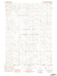
1982 Map of Black Banks Creek West
USGS Topo · Published 1982About this map
Buffalo Gap National Grassland dominates this landscape, showing a complex drainage network where the plains transition across the South Dakota Nebraska border. The topography is defined by ephemeral and perennial watercourses, notably the branching paths of North Black Banks Creek and South Black Banks Creek. These waterways, along with Medicine Creek and Horsehead Creek, illustrate the erosional patterns of the high plains in Fall River Co. In a region where water is a primary shaper of the land, the presence of Dry Lake in the northwest corner highlights the seasonal nature of the local hydrology. This 1982 provisional survey captures the area before modern developments, preserving the layout of unimproved roads and trails that served the ranching interests within the grassland's boundaries.
Find a feature on this map
14 named features on this map. Tap any name to fly to it.
Don’t see what you’re looking for? This feature index may not catch every label — zoom into the map to look around manually.
Map Details
Editions of this 1982 Black Banks Creek West Map
This is the sole edition of this map. No revisions or reprints were ever made.
Other maps of this area

1896 · Oelrichs
USGS Topo · 1:125,000

1900 · Oelrichs
USGS Topo · 1:125,000

1902 · Edgemont
USGS Topo · 1:125,000

1950 · Heppner
USGS Topo · 1:24,000

1955 · Hot Springs
USGS Topo · 1:250,000

1955 · Alliance
USGS Topo · 1:250,000

1957 · Alliance
USGS Topo · 1:250,000

1958 · Alliance
USGS Topo · 1:250,000

1980 · Wolf Butte
USGS Topo · 1:24,000

1980 · Lone Tree Ranch
USGS Topo · 1:24,000