
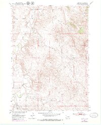
1950 Map of Heppner
USGS Topo · Published 1952About this map
Hat Creek meanders through this portion of Fall River County, defining a landscape of agricultural ranching and drainage networks in the early 1950s. The settlement of Heppner sits in the northern reaches, supported by rural institutions like Maitland Sch and Bunker Hill Sch to the east. The terrain is marked by an extensive system of man-made water controls, with numerous Levee symbols and a specific Spillway along the creek, reflecting mid-century efforts for the development of the Missouri River Basin.
Find a feature on this map
14 named features on this map. Tap any name to fly to it.
Don’t see what you’re looking for? This feature index may not catch every label — zoom into the map to look around manually.
Map Details
Editions of this 1950 Heppner Map
2 editions found
Other maps of this area

1896 · Oelrichs
USGS Topo · 1:125,000

1900 · Oelrichs
USGS Topo · 1:125,000

1902 · Edgemont
USGS Topo · 1:125,000

1950 · Cascade Springs
USGS Topo · 1:24,000

1950 · Angostura Reservoir
USGS Topo · 1:24,000

1950 · Rumford
USGS Topo · 1:24,000

1950 · Flint Hill
USGS Topo · 1:24,000

1955 · Hot Springs
USGS Topo · 1:250,000
1982 · Black Banks Creek West
USGS Topo · 1:25,000
1982 · Ardmore
USGS Topo · 1:25,000