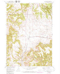
1950 Map of Minnekahta
USGS Topo · Published 1979About this map
The Chicago Burlington and Quincy railroad cuts a prominent path through this 1950s landscape, crossing the high plains of Bradley Flats and the small settlement of Minnekahta. This era of South Dakota land use is defined by a mix of forestry and private ranching, with the Black Hills National Forest boundary intersecting long-established holdings like the Z R Ranch and Johnson Ranch. The topography is marked by significant elevation changes, from the heights of Parker Peak and Matias Peak down into the deep incisions of Chilson Canyon and Stone Quarry Canyon. Water sources such as Cottonwood Springs Creek and Hot Brook drain the highland, while purple map revisions from the late 1970s illustrate the gradual development of the road network and land features since the original 1949 aerial surveys.
Find a feature on this map
22 named features on this map. Tap any name to fly to it.
Don’t see what you’re looking for? This feature index may not catch every label — zoom into the map to look around manually.
Map Details
Editions of this 1950 Minnekahta Map
3 editions found
Other maps of this area

1896 · Harney Peak
USGS Topo · 1:125,000

1901 · Harney Peak
USGS Topo · 1:125,000

1902 · Edgemont
USGS Topo · 1:125,000

1950 · Edgemont
USGS Topo · 1:24,000

1950 · Cascade Springs
USGS Topo · 1:24,000

1950 · Edgemont NE
USGS Topo · 1:24,000

1950 · Minnekahta
USGS Topo · 1:24,000

1950 · Flint Hill
USGS Topo · 1:24,000

1951 · Minnekahta NE
USGS Topo · 1:24,000

1954 · Jewel Cave SE
USGS Topo · 1:24,000