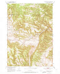
1951 Map of Minnekahta NE
USGS Topo · Published 1973About this map
Harney National Forest dominates this mid-century landscape in Fall River County, where the topography is defined by deep cuts like Booms Canyon and Alabaugh Canyon. The area serves as a rugged gateway near Hot Springs, showing a rural infrastructure built around narrow creek valleys. Transport and education in this period were localized, with the Chicago Burlington and Quincy railroad line following the path of Hot Brook through the center of the quadrangle. The settlement of Erskine sits along these tracks, while remote schoolhouses such as Miller Sch and Cold Brook Sch highlight the dispersed nature of the community. Genealogists may also find interest in the isolated Cem located near the headwaters of Cottonwood Springs Creek, marking the presence of early inhabitants in this high-relief terrain.
Find a feature on this map
12 named features on this map. Tap any name to fly to it.
Don’t see what you’re looking for? This feature index may not catch every label — zoom into the map to look around manually.
Map Details
Editions of this 1951 Minnekahta NE Map
2 editions found

Other maps of this area

1894 · Hermosa
USGS Topo · 1:125,000

1896 · Oelrichs
USGS Topo · 1:125,000

1896 · Harney Peak
USGS Topo · 1:125,000

1900 · Oelrichs
USGS Topo · 1:125,000

1901 · Hermosa
USGS Topo · 1:125,000

1901 · Harney Peak
USGS Topo · 1:125,000

1902 · Edgemont
USGS Topo · 1:125,000

1950 · Hot Springs
USGS Topo · 1:24,000

1950 · Cascade Springs
USGS Topo · 1:24,000

1950 · Angostura Reservoir
USGS Topo · 1:24,000