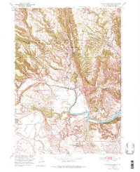
1950 Map of Cascade Springs
USGS Topo · Published 1976About this map
Brainerd Indian Training School and several rural schoolhouses define the social landscape of this Fall River County territory during the mid-century. The topography is dominated by the complex canyon systems of the Harney National Forest, including Alabaugh Canyon and Sheps Canyon, which drain toward the winding Cheyenne River. A significant transformation of the river valley is evident with the presence of the Angostura Reservoir, showing its normal elevation and spillway levels shortly after construction. Local life centers around the thermal features and natural landmarks of the region, such as Cascade Springs, Cascade Falls, and Bridal Veil Spring. The transition from the steep terrain of Stage Hill to the agricultural reaches of Sorghum Flat and Coffee Flat illustrates how early 20th-century settlers adapted their livelihoods to the varied South Dakota breaks.
Find a feature on this map
41 named features on this map. Tap any name to fly to it.
Don’t see what you’re looking for? This feature index may not catch every label — zoom into the map to look around manually.
Map Details
Editions of this 1950 Cascade Springs Map
Other maps of this area

1896 · Oelrichs
USGS Topo · 1:125,000

1900 · Oelrichs
USGS Topo · 1:125,000

1902 · Edgemont
USGS Topo · 1:125,000

1950 · Hot Springs
USGS Topo · 1:24,000

1950 · Heppner
USGS Topo · 1:24,000

1950 · Cascade Springs
USGS Topo · 1:24,000

1950 · Angostura Reservoir
USGS Topo · 1:24,000

1950 · Rumford
USGS Topo · 1:24,000

1950 · Minnekahta
USGS Topo · 1:24,000

1950 · Flint Hill
USGS Topo · 1:24,000