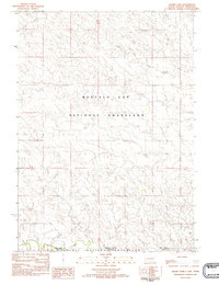
1982 Map of Crowe Dam
USGS Topo · Published 1982About this map
Buffalo Gap National Grassland dominates the northern reaches of this High Plains landscape, where the prairie of Fall River County, South Dakota, meets the Nebraska state line. The terrain is defined by a sparse but vital network of watercourses, including Indian Creek in the south and the drainage of Coal Creek to the northwest. This 1982 provisional survey illustrates a sparsely populated ranching and grazing region near the border, characterized by remote tank sites and scattered improvements across the grasslands. The state boundary serves as a transition between federal lands, with the Oglala National Grassland extending into Sioux County, Nebraska. Local hydrological features like the North Fork Duck Creek and Duck Creek provide essential relief in this arid environment, centered around the eponymous Crowe Dam.
Find a feature on this map
9 named features on this map. Tap any name to fly to it.
Don’t see what you’re looking for? This feature index may not catch every label — zoom into the map to look around manually.
Map Details
Editions of this 1982 Crowe Dam Map
This is the sole edition of this map. No revisions or reprints were ever made.
Other maps of this area

1902 · Edgemont
USGS Topo · 1:125,000

1950 · Rumford
USGS Topo · 1:24,000

1955 · Hot Springs
USGS Topo · 1:250,000

1955 · Alliance
USGS Topo · 1:250,000

1957 · Alliance
USGS Topo · 1:250,000

1958 · Alliance
USGS Topo · 1:250,000

1980 · Montrose
USGS Topo · 1:24,000
1980 · Story
USGS Topo · 1:24,000
1980 · Story NE
USGS Topo · 1:24,000
1982 · Provo
USGS Topo · 1:25,000