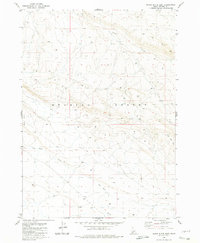
1980 Map of Black Butte East
USGS Topo · Published 1980About this map
Bruneau Desert dominates this high plateau region in Owyhee County, where the 1980 landscape is defined by vast drainage systems and scattered ranching improvements. Evidence of seasonal water and livestock management is central to the area's utility, marked by a lone Corral situated near the headwaters of Pot Hole Creek. These seasonal channels, along with Sailor Creek and the notable rise of The Big Hill, illustrate the complex drainage patterns required to navigate this arid environment. The map shows a network of Trail and Jeep tracks that provide the only passage across the tablelands, connecting high points like Black Butte to the surrounding basins. This topographic record preserves the remote character of the Idaho desert before modern developments altered many traditional rangeland access points.
Find a feature on this map
8 named features on this map. Tap any name to fly to it.
Don’t see what you’re looking for? This feature index may not catch every label — zoom into the map to look around manually.
Map Details
Editions of this 1980 Black Butte East Map
This is the sole edition of this map. No revisions or reprints were ever made.
Other maps of this area

1948 · Twentymile Butte
USGS Topo · 1:24,000

1948 · Glenns Ferry
USGS Topo · 1:62,500

1948 · Grindstone Butte
USGS Topo · 1:24,000
1949 · Pot Hole Canyon
USGS Topo · 1:24,000
1949 · Grindstone Butte
USGS Topo · 1:24,000

1949 · Pasadena Valley
USGS Topo · 1:62,500
1951 · Glenns Ferry
USGS Topo · 1:62,500

1955 · Twin Falls
USGS Topo · 1:250,000

1956 · Blue Butte
USGS Topo · 1:62,500

1958 · Twin Falls
USGS Topo · 1:250,000