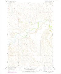
1956 Map of Black Horse
USGS Topo · Published 1978About this map
The Grand River meanders across this mid-century landscape within the Standing Rock Indian Reservation, serving as the central geographic feature for the small settlement of Black Horse. The surrounding terrain is defined by a network of drainage systems including Lodge Creek, Louse Creek, and Little Soldier Creek, which carve through the high plains toward the river valley. In the southern portion of the quadrangle, the Liberty district includes the isolated Pleasant View Sch, a localized hub for the rural community during this era. Prominent landmarks such as Clay Butte provide navigational points in a region largely characterized by its open, grassy expanses and sparse development. This survey, updated with 1970s aerial photography, documents a period before significant modern changes, preserving the locations of remote schools and creek crossings essential to the local ranching economy.
Find a feature on this map
10 named features on this map. Tap any name to fly to it.
Don’t see what you’re looking for? This feature index may not catch every label — zoom into the map to look around manually.
Map Details
Editions of this 1956 Black Horse Map
2 editions found
Other maps of this area

1953 · McIntosh
USGS Topo · 1:250,000

1956 · Black Horse NE
USGS Topo · 1:24,000

1956 · Black Horse SW
USGS Topo · 1:24,000

1956 · Cottonwood Creek NE
USGS Topo · 1:24,000

1956 · Black Horse SE
USGS Topo · 1:24,000

1956 · Black Horse
USGS Topo · 1:24,000

1956 · Cottonwood Creek SE
USGS Topo · 1:24,000

1958 · McIntosh
USGS Topo · 1:250,000

1972 · McIntosh SW
USGS Topo · 1:24,000

1972 · Morristown SE
USGS Topo · 1:24,000