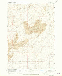
1965 Map of Black Knoll
USGS Topo · Published 1967About this map
Sand Dunes dominate this high-desert landscape in Fremont County, where complex topographical contours reveal the shifting geomorphology of the region during the mid-1960s. The prominent rising landform of Black Knoll serves as a stationary landmark amidst the sea of dunes that stretch across the central and western portions of the quadrangle. In this arid environment, human presence is sparse and strictly functional, evidenced by the intermittent channel of Sand Creek and a solitary Well located in the northern flats. The map reflects a moment in time before modern irrigation or development significantly altered the drainage patterns of these semi-arid lands, showing a primitive road network that largely skirts the most significant dune fields and highlights the isolation of this corner of eastern Idaho.
Find a feature on this map
4 named features on this map. Tap any name to fly to it.
Don’t see what you’re looking for? This feature index may not catch every label — zoom into the map to look around manually.
Map Details
Editions of this 1965 Black Knoll Map
This is the sole edition of this map. No revisions or reprints were ever made.
Other maps of this area

1948 · Parker
USGS Topo · 1:24,000

1949 · Newdale
USGS Topo · 1:24,000

1950 · Parker
USGS Topo · 1:24,000

1950 · Newdale
USGS Topo · 1:24,000

1950 · St Anthony
USGS Topo · 1:24,000

1955 · Ashton
USGS Topo · 1:250,000

1955 · Driggs
USGS Topo · 1:250,000

1958 · Driggs
USGS Topo · 1:250,000

1958 · Ashton
USGS Topo · 1:250,000

1960 · Ashton
USGS Topo · 1:250,000