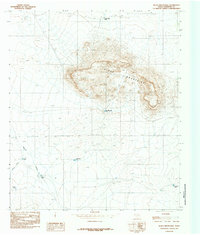
1984 Map of Black Mountains
USGS Topo · Published 1985About this map
The Black Mountains rise as a prominent landform in this arid portion of Hudspeth County, their central peaks and ridges providing a stark contrast to the surrounding drainage basins. This mid-1980s provisional study emphasizes the critical importance of water management in the high desert, documenting a network of livestock tanks and catchments necessary for ranching and survival. Features like Cuatro Julio Tank and the Black Mountain Tank are strategically positioned around the central massif to collect runoff from the rocky slopes. To the west and south, the terrain levels out into expansive draws, including the significant path of Miller Draw. The distribution of man-made catchments such as Flat Bottom Tank, Bond Tank, and Dishpan Tank indicates a landscape primarily utilized for grazing, where every natural basin and drainage was surveyed for its potential to support local range operations.
Find a feature on this map
9 named features on this map. Tap any name to fly to it.
Don’t see what you’re looking for? This feature index may not catch every label — zoom into the map to look around manually.
Map Details
Editions of this 1984 Black Mountains Map
This is the sole edition of this map. No revisions or reprints were ever made.
Other maps of this area

1895 · Sierra Blanca
USGS Topo · 1:125,000

1948 · Triple Hill
USGS Topo · 1:62,500

1951 · Red Hills
USGS Topo · 1:62,500

1954 · Van Horn
USGS Topo · 1:250,000

1955 · Black Mountains
USGS Topo · 1:62,500

1958 · Van Horn
USGS Topo · 1:250,000

1973 · Norton Mesa
USGS Topo · 1:24,000

1973 · Sneed Mountain NE
USGS Topo · 1:24,000
1979 · Black Hills
USGS Topo · 1:24,000
1984 · Babb Canyon
USGS Topo · 1:24,000