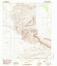
1984 Map of Babb Canyon
USGS Topo · Published 1985About this map
The Sierra Diablo Rim dominates this high-altitude corner of West Texas, creating a dramatic geographic boundary across the landscape. The terrain is characterized by steep escarpments and elevated plateaus, most notably Flattop Mountain and the adjacent Little South Mesa. In this arid environment, the survival of ranching operations is evidenced by a network of water collection points bearing local names, such as Kuykendall Tank, Patterson Tank, and Mc Adoo Tank. These features, along with Babb Canyon, illustrate how the natural topography dictates the movement and placement of infrastructure. The presence of a small Gravel Pit and various unimproved trails suggests a region focused on resource extraction and seasonal grazing rather than permanent settlement, providing a detailed look at the rural land management practices of Hudspeth County in the early 1980s.
Find a feature on this map
12 named features on this map. Tap any name to fly to it.
Don’t see what you’re looking for? This feature index may not catch every label — zoom into the map to look around manually.
Map Details
Editions of this 1984 Babb Canyon Map
This is the sole edition of this map. No revisions or reprints were ever made.
Other maps of this area

1895 · Sierra Blanca
USGS Topo · 1:125,000

1906 · Van Horn
USGS Topo · 1:125,000

1954 · Van Horn
USGS Topo · 1:250,000

1955 · Black Mountains
USGS Topo · 1:62,500

1958 · Van Horn
USGS Topo · 1:250,000

1973 · Bitter Well Mountain NW
USGS Topo · 1:24,000

1973 · Norton Mesa
USGS Topo · 1:24,000

1973 · Bitter Well Mountain SW
USGS Topo · 1:24,000

1973 · Sneed Mountain NE
USGS Topo · 1:24,000

1973 · Apache Peak
USGS Topo · 1:24,000