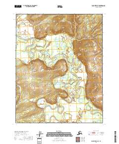
2018 Map of Black River C-4 SE
USGS Topo · Published 2018About this map
The Draanjik River meanders across this vast alluvial landscape, creating a complex network of oxbow lakes and side channels in the Yukon-Koyukuk region. This 2018 survey documents a remote stretch of the Alaska interior, where the river’s shifting course is traced by features like Vachahyanande Slough. To the east, the terrain transitions from the low-lying wetlands of the river valley toward the prominent rising elevation of Vacahanyande Mtn.
Find a feature on this map
10 named features on this map. Tap any name to fly to it.
Don’t see what you’re looking for? This feature index may not catch every label — zoom into the map to look around manually.
Map Details
Editions of this 2018 Black River C-4 SE Map
This is the sole edition of this map. No revisions or reprints were ever made.
Other maps of this area

1951 · Black River
USGS Topo · 1:250,000

1956 · Black River B-3
USGS Topo · 1:63,360

1956 · Black River B-4
USGS Topo · 1:63,360

1956 · Black River C-4
USGS Topo · 1:63,360

1956 · Black River C-3
USGS Topo · 1:63,360

1956 · Black River
USGS Topo · 1:250,000

1964 · Black River
USGS Topo · 1:250,000
2018 · Black River C-3 NW
USGS Topo · 1:25,000
2018 · Black River B-3 NW
USGS Topo · 1:25,000
2018 · Black River C-4 NE
USGS Topo · 1:25,000