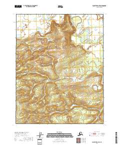
2018 Map of Black River C-4 SW
USGS Topo · Published 2018About this map
Nelson Bluff rises above the meandering course of the Draanjik River in this sparsely settled region of the Yukon-Koyukuk Census Area. The terrain is characterized by intricate elevation contours that define the high ground of the bluff against the surrounding river valley and lowlands. This 2018 survey by the U.S. Geological Survey reflects a landscape primarily defined by its natural watercourses and topography rather than human infrastructure. The layout is organized through the Public Land Survey System, with township and range lines like t21n r22e and t20n r23e providing a grid for land management in this remote part of the Alaska interior. The absence of named roads or settlements emphasizes the wilderness character of the area during the early twenty-first century.
Find a feature on this map
8 named features on this map. Tap any name to fly to it.
Don’t see what you’re looking for? This feature index may not catch every label — zoom into the map to look around manually.
Map Details
Editions of this 2018 Black River C-4 SW Map
This is the sole edition of this map. No revisions or reprints were ever made.
Other maps of this area

1951 · Black River
USGS Topo · 1:250,000

1956 · Black River B-5
USGS Topo · 1:63,360

1956 · Black River B-4
USGS Topo · 1:63,360

1956 · Black River C-5
USGS Topo · 1:63,360

1956 · Black River C-4
USGS Topo · 1:63,360

1956 · Black River
USGS Topo · 1:250,000

1964 · Black River
USGS Topo · 1:250,000
2018 · Black River C-4 NE
USGS Topo · 1:25,000
2018 · Black River B-4 NE
USGS Topo · 1:25,000
2018 · Black River C-4 NW
USGS Topo · 1:25,000