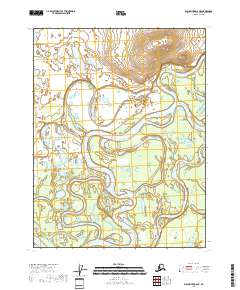
2018 Map of Black River D-6 NE
USGS Topo · Published 2018About this map
The Porcupine River dominates this portion of the Yukon-Koyukuk Census Area, winding through a complex system of active and secondary waterways. This interior Alaskan landscape is defined by the shifting course of the river, where the Middle Channel Porcupine River and numerous sloughs create a dense network of braided channels and seasonal ponds. Small bodies of water like Rat Lake sit in the low-lying areas, typical of the wetland ecology of this region. Navigational features such as Joe Ward Slough, Rook Slough, and the extensive Henderson Slough illustrate the dynamic hydrological patterns of the river basin, where water levels and channel paths are in constant flux across the various sections of T24N and T25N.
Find a feature on this map
11 named features on this map. Tap any name to fly to it.
Don’t see what you’re looking for? This feature index may not catch every label — zoom into the map to look around manually.
Map Details
Editions of this 2018 Black River D-6 NE Map
This is the sole edition of this map. No revisions or reprints were ever made.
Other maps of this area

1951 · Black River
USGS Topo · 1:250,000

1951 · Coleen
USGS Topo · 1:250,000

1956 · Coleen
USGS Topo · 1:250,000

1956 · Black River D-6
USGS Topo · 1:63,360

1956 · Coleen A-5
USGS Topo · 1:63,360

1956 · Black River D-5
USGS Topo · 1:63,360
1956 · Coleen A-6
USGS Topo · 1:63,360

1956 · Black River
USGS Topo · 1:250,000

1964 · Black River
USGS Topo · 1:250,000
2018 · Coleen A-5 SW
USGS Topo · 1:25,000