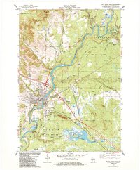
1984 Map of Black River Falls
USGS Topo · Published 1984About this map
Black River Falls serves as the focal point of this 1980s landscape, where the Black River carves through a region defined by its timber heritage and unique agriculture. The town's grid expands toward the Chicago and North Western rail line, which cuts southeast across the terrain. Extensive Cranberry Bogs and the smaller Cranberry Bog to the south illustrate the specialized wetlands that characterize this part of Jackson County. Public lands are prominent, with the Black River State Forest and Komensky State Forest flanking the river valley.
Find a feature on this map
56 named features on this map. Tap any name to fly to it.
Don’t see what you’re looking for? This feature index may not catch every label — zoom into the map to look around manually.
Map Details
Editions of this 1984 Black River Falls Map
This is the sole edition of this map. No revisions or reprints were ever made.
Other maps of this area

1924 · Black River Falls
USGS Topo · 1:62,500

1926 · Black River Falls
USGS Topo · 1:62,500

1928 · Melrose
USGS Topo · 1:48,000

1947 · Millston
USGS Topo · 1:62,500

1949 · Millston
USGS Topo · 1:62,500

1949 · Melrose
USGS Topo · 1:62,500

1953 · Eau Claire
USGS Topo · 1:250,000

1958 · Eau Claire
USGS Topo · 1:250,000

1958 · Hatfield
USGS Topo · 1:48,000

1964 · Eau Claire
USGS Topo · 1:250,000