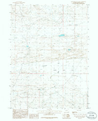
1986 Map of Black Rock Flat West
USGS Topo · Published 1986About this map
Black Rock Flat and the adjacent Alkali Basin define this arid corner of Sweetwater County, where the high desert landscape is etched by intermittent drainages. A network of unimproved roads and trails provides access to isolated water sources like Flowing Well and several unnamed wells, which were vital for livestock and survival in this water-scarce region. The terrain is characterized by shifting Sand Dunes and seasonal features such as Dry Lake and Greasewood Wash. Human activity is minimal, represented primarily by a Gravel Pit and survey markers, suggesting a landscape primarily used for grazing and resource extraction. The presence of Black Rock Creek cutting through the center of the flats highlights the importance of seasonal hydrology in shaping the geography of the Wyoming basins during the late twentieth century.
Find a feature on this map
10 named features on this map. Tap any name to fly to it.
Don’t see what you’re looking for? This feature index may not catch every label — zoom into the map to look around manually.
Map Details
Editions of this 1986 Black Rock Flat West Map
This is the sole edition of this map. No revisions or reprints were ever made.
Other maps of this area

1954 · Rock Springs
USGS Topo · 1:250,000

1955 · Lander
USGS Topo · 1:250,000

1958 · Lander
USGS Topo · 1:250,000

1958 · Rock Springs
USGS Topo · 1:250,000

1958 · Twelvemile Well
USGS Topo · 1:62,500

1958 · Freighter Gap
USGS Topo · 1:62,500

1958 · The Pinnacles
USGS Topo · 1:62,500

1958 · Superior
USGS Topo · 1:62,500

1961 · Lander
USGS Topo · 1:250,000

1962 · Rock Springs
USGS Topo · 1:250,000