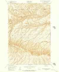
1953 Map of Black Rock Spring NE
USGS Topo · Published 1957About this map
Yakima Firing Center Military Reservation dominates this 1953 survey, illustrating a landscape primarily dedicated to military training and open rangeland. The topography is defined by the significant rise of Umtanum Ridge, which separates the high desert plains from the complex drainage systems to the north and east. Sparse evidence of permanent human settlement is visible, with only the Stewart Ranch appearing in the center of the sheet, providing a rare genealogical marker for family researchers in this part of Washington. The rugged geography is further detailed by deep seasonal cuts like Alkali Canyon and Corral Canyon. These natural features, along with Sourdough Canyon and Cow Canyon, highlight the drainage patterns through the high country where the border between Kittitas and Yakima Counties is established.
Find a feature on this map
8 named features on this map. Tap any name to fly to it.
Don’t see what you’re looking for? This feature index may not catch every label — zoom into the map to look around manually.
Map Details
Editions of this 1953 Black Rock Spring NE Map
2 editions found
Other maps of this area

1912 · Beverly
USGS Topo · 1:62,500

1917 · Priest Rapids
USGS Topo · 1:62,500

1936 · Hog Ranch Buttes
USGS Topo · 1:48,000

1939 · Boylston
USGS Topo · 1:48,000

1941 · Black Rock Spring
USGS Topo · 1:62,500

1943 · Boylston
USGS Topo · 1:62,500

1948 · Cairn Hope Peak
USGS Topo · 1:24,000

1948 · Priest Rapids
USGS Topo · 1:24,000

1950 · Yakima
USGS Topo · 1:250,000

1951 · Priest Rapids
USGS Topo · 1:62,500