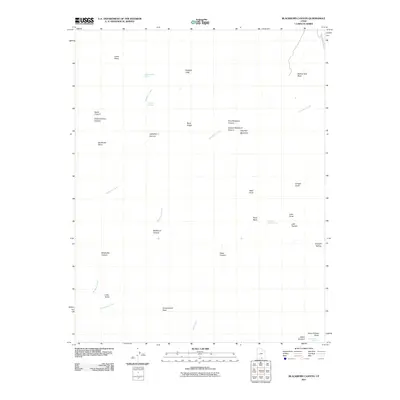
2011 Map of Blackburn Canyon
USGS Topo · Published 2011About this map
Hole In The Rock Rd skirts the northeastern corner of this landscape, marking a path through the high desert of Kane County. The terrain is defined by a complex network of drainages and vertical reliefs, where Straight Cliffs and the mass of Fiftymile Mountain overlook deep incisions like Llewellyn Canyon and Gates Canyon. Water remains the critical scarce resource of the region, anchored by named points such as Pocket Hollow Spring, Mudhole Spring, and Pleasant Grove Spring. These features, along with Indian Gardens at the southern edge, trace a history of travel and survival in a territory where the geography of the bench and canyon dictates all movement. To the south, the Grand Bench Neck narrows between the winding courses of Rock Creek and Blackburn Creek, illustrating the dramatic erosion that characterizes this part of the Colorado Plateau.
Find a feature on this map
33 named features on this map. Tap any name to fly to it.
Don’t see what you’re looking for? This feature index may not catch every label — zoom into the map to look around manually.
Map Details
Editions of this 2011 Blackburn Canyon Map
This is the sole edition of this map. No revisions or reprints were ever made.
Other maps of this area

1886 · Escalante
USGS Topo · 1:250,000

1922 · Warm Creek
USGS Topo · 1:63,360

1922 · Rees Canyon
USGS Topo · 1:63,360

1953 · Cummings Mesa
USGS Topo · 1:62,500

1953 · Gunsight Butte
USGS Topo · 1:62,500

1956 · Escalante
USGS Topo · 1:250,000

1960 · Escalante
USGS Topo · 1:250,000

1968 · East of The Navajo
USGS Topo · 1:24,000
1968 · Big Hollow Wash
USGS Topo · 1:24,000
1968 · Basin Canyon
USGS Topo · 1:24,000