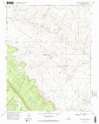
1968 Map of Big Hollow Wash
USGS Topo · Published 1971About this map
Straight Cliffs and the elevated plateau of Fiftymile Mountain define this landscape in Kane County, Utah. The 1968 field check reveals a network of water sources critical for survival in the high desert, ranging from Big Hollow Spring to Orins Well. The map captures a complex system of drainage and erosion, where Dry Fork Coyote Gulch and Brimstone Gulch carve through the Scorpion and Cat Pasture regions. Man-made infrastructure is sparse, consisting primarily of primitive transportation routes like the Pack Trail and various Jeep Trails that navigate the varied elevations between Fiftymile Bench and the lower washes. This topographic study emphasizes the importance of reliable water points like Coyote Hole and Red Well for those traversing the formidable terrain of the Escalante region before modern development.
Find a feature on this map
28 named features on this map. Tap any name to fly to it.
Don’t see what you’re looking for? This feature index may not catch every label — zoom into the map to look around manually.
Map Details
Editions of this 1968 Big Hollow Wash Map
2 editions found
Other maps of this area

1886 · Escalante
USGS Topo · 1:250,000

1922 · Rees Canyon
USGS Topo · 1:63,360

1953 · Circle Cliffs 4 SW
USGS Topo · 1:24,000

1953 · Moody Creek
USGS Topo · 1:62,500

1956 · Escalante
USGS Topo · 1:250,000

1960 · Escalante
USGS Topo · 1:250,000

1964 · Sunset Flat
USGS Topo · 1:24,000

1968 · East of The Navajo
USGS Topo · 1:24,000
1968 · Basin Canyon
USGS Topo · 1:24,000
1968 · Blackburn Canyon
USGS Topo · 1:24,000