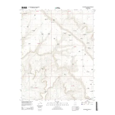
2014 Map of Blackburn Canyon
USGS Topo · Published 2014About this map
Straight Cliffs dominate the northern landscape of this Kane County region, creating a stark vertical divide between the upper plateaus and the canyon systems below. The drainage network is defined by seasonal watercourses like Mudhole Cr and Blackburn Cr, which have carved intricate systems such as First Blackburn Canyon and Second Blackburn Canyon into the plateau. The presence of Indian Gardens in the southeast suggests a location of perennial water or shelter, supported by nearby features like Harry Spring and Pool Hollow. To the west, the terrain transitions into the broader Little Valley, while landmarks like Window Wind Arch and Cougar Knoll serve as prominent navigational markers. This map captures a complex system of livestock grazing lands and remote water sources, including Lake Pasture and Pinto Mare, centered around the high elevation of Fiftymile Mtn.
Find a feature on this map
50 named features on this map. Tap any name to fly to it.
Don’t see what you’re looking for? This feature index may not catch every label — zoom into the map to look around manually.
Map Details
Editions of this 2014 Blackburn Canyon Map
This is the sole edition of this map. No revisions or reprints were ever made.
Other maps of this area

1886 · Escalante
USGS Topo · 1:250,000

1922 · Warm Creek
USGS Topo · 1:63,360

1922 · Rees Canyon
USGS Topo · 1:63,360

1953 · Cummings Mesa
USGS Topo · 1:62,500

1953 · Gunsight Butte
USGS Topo · 1:62,500

1956 · Escalante
USGS Topo · 1:250,000

1960 · Escalante
USGS Topo · 1:250,000

1968 · East of The Navajo
USGS Topo · 1:24,000
1968 · Big Hollow Wash
USGS Topo · 1:24,000
1968 · Basin Canyon
USGS Topo · 1:24,000