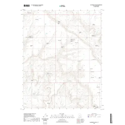
2020 Map of Blackburn Canyon
USGS Topo · Published 2020About this map
Kaiparowits Plateau and its dramatic eastern edge at the Straight Cliffs dominate this section of Kane County. The terrain is defined by a series of erosional benches and deep drainages, including the Fiftymile Mtn and Fiftymile Bench corridor. Water sources are critical landmarks in this arid landscape, with Gates Spring, Pocket Hollow Spring, and Harry Colwes Spring indicating historical points of reliance for cattlemen and travelers. The complex network of canyons, such as Blackburn Canyon and Llewellyn Canyon, flows toward the Colorado River system, while features like Indian Gardens and the Grand Bench Neck suggest the enduring importance of specific trail access points and grazing areas. Notable geological features like Window Wind Arch and the high vantage at Steer Point serve as prominent navigational aids across the broken topography.
Find a feature on this map
42 named features on this map. Tap any name to fly to it.
Don’t see what you’re looking for? This feature index may not catch every label — zoom into the map to look around manually.
Map Details
Editions of this 2020 Blackburn Canyon Map
This is the sole edition of this map. No revisions or reprints were ever made.
Other maps of this area

1886 · Escalante
USGS Topo · 1:250,000

1922 · Warm Creek
USGS Topo · 1:63,360

1922 · Rees Canyon
USGS Topo · 1:63,360

1953 · Cummings Mesa
USGS Topo · 1:62,500

1953 · Gunsight Butte
USGS Topo · 1:62,500

1956 · Escalante
USGS Topo · 1:250,000

1960 · Escalante
USGS Topo · 1:250,000

1968 · East of The Navajo
USGS Topo · 1:24,000
1968 · Big Hollow Wash
USGS Topo · 1:24,000
1968 · Basin Canyon
USGS Topo · 1:24,000