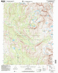
2004 Map of Blackcap Mountain
USGS Topo · Published 2007About this map
The North Fork Kings River winds through the high-elevation terrain of the Sierra National Forest and the John Muir Wilderness, revealing a landscape defined by glacial basins and alpine meadows. The high ridge of the Le Conte Divide serves as the boundary for Kings Canyon National Park to the east, while the central portion of the sheet is anchored by Blackcap Mountain and the expansive Blackcap Basin.
Find a feature on this map
70 named features on this map. Tap any name to fly to it.
Don’t see what you’re looking for? This feature index may not catch every label — zoom into the map to look around manually.
Map Details
Editions of this 2004 Blackcap Mountain Map
This is the sole edition of this map. No revisions or reprints were ever made.
Other maps of this area

1903 · Tehipite
USGS Topo · 1:125,000

1905 · Tehipite
USGS Topo · 1:125,000

1912 · Mt. Goddard
USGS Topo · 1:125,000

1947 · Mariposa
USGS Topo · 1:250,000

1948 · Fresno
USGS Topo · 1:250,000

1948 · Mariposa
USGS Topo · 1:250,000

1948 · Mt. Goddard
USGS Topo · 1:62,500

1951 · Mt. Goddard
USGS Topo · 1:62,500

1952 · Mt. Goddard
USGS Topo · 1:62,500

1952 · Tehipite Dome
USGS Topo · 1:62,500