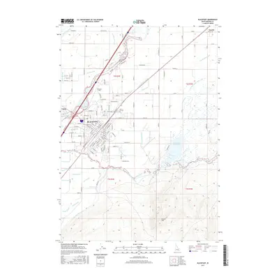
2017 Map of Blackfoot
USGS Topo · Published 2017About this map
The Blackfoot city center serves as the hub of this Idaho landscape, where the Snake River and Blackfoot River converge amidst a dense network of early 21st-century irrigation infrastructure. This intricate system of water management is defined by numerous channels including the Fort Hall Main Canal, Corbett Slough Canal, and New Lakeside Ditch, illustrating the region's total reliance on diverted water for agriculture. To the north, the small settlement of Wapello and the historic Porterville Bridge mark the transition toward more open rural lands, while the Grove City Cem and McCarley Field anchor the community's local history and infrastructure. The southern portion of the sheet rises toward Stevens Peak, overlooking the Equalizing Reservoir and a series of specialized irrigation laterals such as the Apex Lateral and Neva Lateral, which demonstrate the sophisticated engineering required to sustain the high desert plain.
Find a feature on this map
105 named features on this map. Tap any name to fly to it.
Don’t see what you’re looking for? This feature index may not catch every label — zoom into the map to look around manually.
Map Details
Editions of this 2017 Blackfoot Map
This is the sole edition of this map. No revisions or reprints were ever made.
Other maps of this area

1940 · Blackfoot
USGS Topo · 1:62,500

1943 · Blackfoot
USGS Topo · 1:62,500

1955 · Baldy Knoll
USGS Topo · 1:24,000

1955 · Lincoln Creek
USGS Topo · 1:24,000

1955 · Rose
USGS Topo · 1:24,000

1955 · Firth
USGS Topo · 1:24,000

1955 · Yandell Springs
USGS Topo · 1:62,500

1955 · Idaho Falls
USGS Topo · 1:250,000

1958 · Idaho Falls
USGS Topo · 1:250,000
1971 · Fort Hall
USGS Topo · 1:24,000