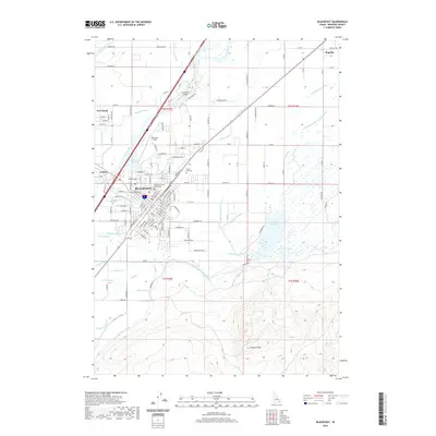
2020 Map of Blackfoot
USGS Topo · Published 2020About this map
The city of Blackfoot serves as the focal point of this Eastern Idaho landscape, situated near the confluence of the Snake River and the Blackfoot River. The layout of the town is detailed through its grid of streets, including landmarks like the Bingham County Courthouse and McCarley Field. Beyond the city center, the agricultural character of the region is defined by a dense network of irrigation infrastructure, such as the Danskin Canal, Riverside Canal, and Fort Hall Main Canal. These water systems, alongside numerous ditches and laterals, underscore the intensive land management required in the Snake River Plain.
Find a feature on this map
79 named features on this map. Tap any name to fly to it.
Don’t see what you’re looking for? This feature index may not catch every label — zoom into the map to look around manually.
Map Details
Editions of this 2020 Blackfoot Map
This is the sole edition of this map. No revisions or reprints were ever made.
Other maps of this area

1940 · Blackfoot
USGS Topo · 1:62,500

1943 · Blackfoot
USGS Topo · 1:62,500

1955 · Baldy Knoll
USGS Topo · 1:24,000

1955 · Lincoln Creek
USGS Topo · 1:24,000

1955 · Rose
USGS Topo · 1:24,000

1955 · Firth
USGS Topo · 1:24,000

1955 · Yandell Springs
USGS Topo · 1:62,500

1955 · Idaho Falls
USGS Topo · 1:250,000

1958 · Idaho Falls
USGS Topo · 1:250,000
1971 · Fort Hall
USGS Topo · 1:24,000