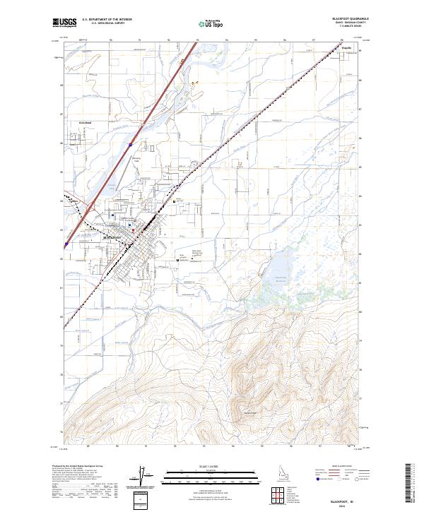
2024 Map of Blackfoot
USGS Topo · Published 2024About this map
Blackfoot serves as the focal point of this Bingham County landscape, situated at the confluence of the Snake River and the Blackfoot River. The layout of the city reveals its importance as a local administrative hub, anchored by the Bingham County Courthouse and supported by institutional facilities such as Idaho State Hospital South. To the north and west, the smaller communities of Wapello, Groveland, and Collins are interspersed among a dense network of irrigation infrastructure. This intricate system of waterways, including the Danskin Canal, Corbett Slough Canal, and the Fort Hall Main Canal, illustrates the intensive agricultural development of the Snake River Plain. The terrain transitions from these managed lowlands to the more prominent elevations of Stevens Peak and Little Butte in the southeast. Notable local landmarks like McCarley Field and the Idaho State Veterans Cem at Blackfoot provide specific points of reference for those researching modern family history or civic development in the region.
Find a feature on this map
145 named features on this map. Tap any name to fly to it.
Don’t see what you’re looking for? This feature index may not catch every label — zoom into the map to look around manually.
Map Details
Editions of this 2024 Blackfoot Map
This is the sole edition of this map. No revisions or reprints were ever made.
Other maps of this area

1940 · Blackfoot
USGS Topo · 1:62,500

1943 · Blackfoot
USGS Topo · 1:62,500

1955 · Baldy Knoll
USGS Topo · 1:24,000

1955 · Lincoln Creek
USGS Topo · 1:24,000

1955 · Rose
USGS Topo · 1:24,000

1955 · Firth
USGS Topo · 1:24,000

1955 · Yandell Springs
USGS Topo · 1:62,500

1955 · Idaho Falls
USGS Topo · 1:250,000

1958 · Idaho Falls
USGS Topo · 1:250,000
1971 · Fort Hall
USGS Topo · 1:24,000